")
At their February 2021 zoom meeting, Grampaw Pettibone Squadron and Two Block Fox Squadron hosted a presentation by Wayne R. Scott, USAF (ret). Wayne spoke about the Joint Precision Approach and Landing System (JPALS). He served over 29 years as a Communications and Computer Systems Officer in the United States Air Force. After leaving the Air Force, he became a Program Manager for the Raytheon Corporation and led the US Navy’s Joint Precision Approach and Landing System (JPALS) program. He retired from Raytheon in 2019.
Why did a retired Air Force Officer become involved with a system associated with The US Navy?
Wayne explained that his motivation was driven by his father, who had been a US Navy jet pilot, flying off aircraft carriers. He noted that “naval aviation blood has been in his system from the start”.
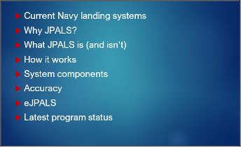
Naval aviation has inherent risks and hazards and is dangerous, particularly when landing a plane on an aircraft carrier. The following is a list of the topics for the presentation.
CURRENT NAVY LANDING SYSTEM
The approach and landing systems used by the Navy till the introduction of JPALS, were made up of a number of different features. The following image provided the foundation for JPALS.
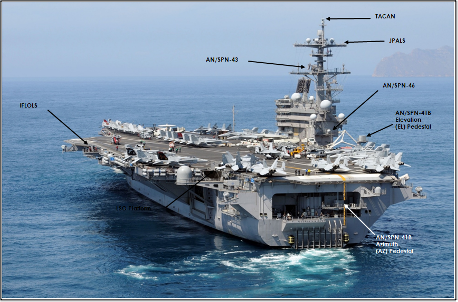
The most common is a visual approach using the pilot eyes. This is an optical landing system (OLS) (nicknamed “meatball” or simply, “Ball”) and is used to give visual glidepath information to pilots in the terminal phase of landing on an aircraft carrier.
The onboard systems are comprised of the following: TACAN (Tactical Aid to Navigation), which provides bearing to and from the ship as well as range. Another system comprised of two different units: one is located for elevation (EL) on a pedestal on the Starboard side of the carrier deck, and one, for azimuth(AZ) located below the deck and at the approach end, and is called the AN/SPN-41B (Spin 41), which provides signals to approaching Navy and Marine Corps aircraft. Also, on the starboard side of the deck is the AN/SPN-46 (Spin 46), which is Precision Approach Radar, where a controller can verbally talk a pilot down to a touch-down. Finally, the AN/SPN-43 (Spin 43), is the Navy’s marshalling air traffic control system for vectoring aircraft into final approach.
WHY JPALS?
Each of the previous systems identified, provides modest accuracy and requires a strong broadcast signal to aid aircraft in locating the carrier and landing. However, the radio frequency (RF) signal strength also poses a defensive risk during military operations and may be shut down to protect the fleet, which poses operational challenges for returning aircraft. A system was needed to replace this older technology that had improved operational accuracy and not require a broadcast signal to aid landing aircraft.
WHAT IS JPALS?
The system to be discussed is a GPS based operation with far greater accuracy for landing aircraft. The system is currently installed on F-35B/C, and planned for the Sting Ray unmanned tanker. This will support landing on aircraft carriers (CVN) and amphibious assault ships (LH). JPALS can be used by a flight controller to Autoland an aircraft. This could be employed if weather conditions, rough seas or pilot incapacity prevent a safe landing. The goal of this program is reduced pilot work load.
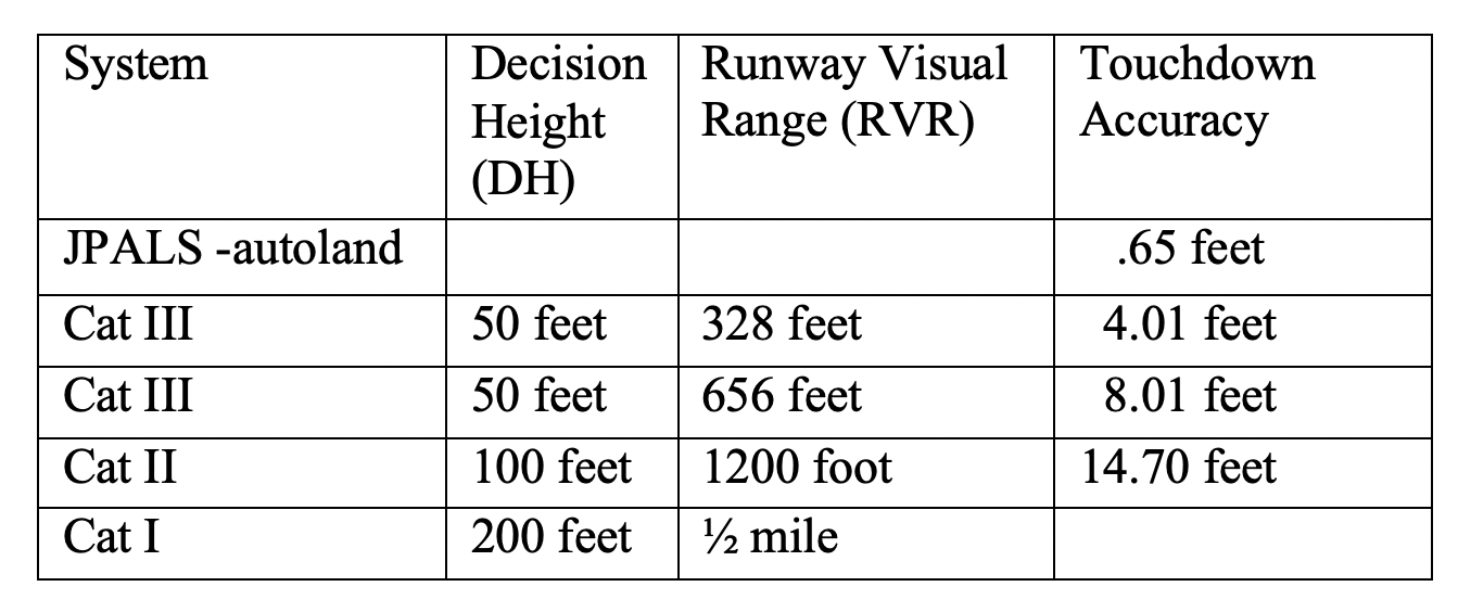
A comparison of current and future systems are as follows:
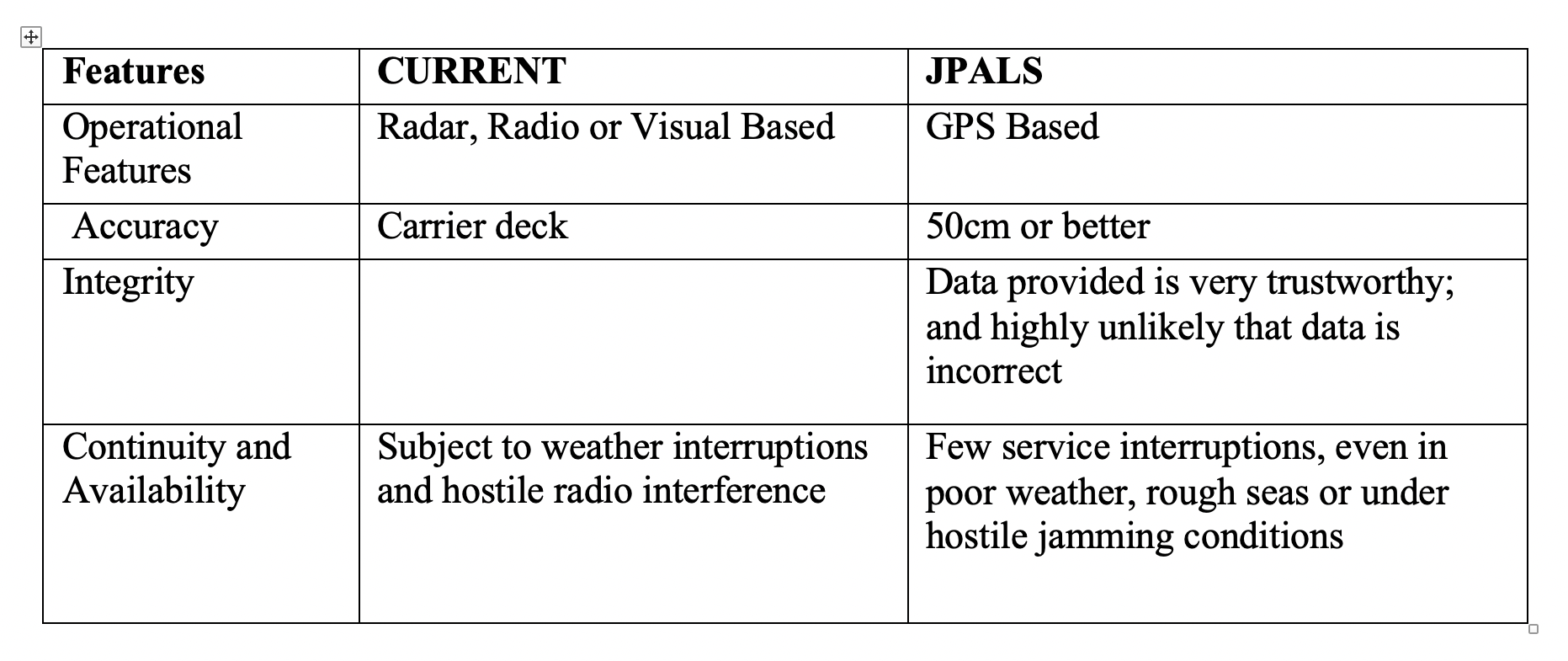
A project incentive accuracy test in 2013 demonstrated that after 20 consecutive landings, touchdown accuracy was 20cm or better. The JPALS system integrity, as described by Wayne, is noted as 99.998% reliable.
WHAT JPALS ISN’T
- JPALS is not a flight controller. It does not send control commands to direct the pilot in flying the aircraft. It is not an autopilot for a pilot to use when landing an aircraft. It does not function as an autopilot and support unmanned vehicles (UAV) by providing navigation guidance to the UAV pilot to land the aircraft.
- JPALS is not a program called MAGIC CARPET (Maritime Augmented Guidance with Integrated Controls for Carrier Approach and Recovery Precision Enabling Technologies). It was subsequently renamed PLM (Precision Landing Mode).
- PLM is only available for the F/A-18E/F/G. It must be switched on by the pilot, who uses existing legacy landing systems and does not give greater precision then already available. It adds and reduces power, adjusts pitch, yaw and roll, while the pilot controls the flight path. The computer makes the fine adjustments of angle, speed and alignment to stay on the flight path selected by the pilot.
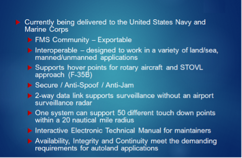
JPALS Key Features
HOW IT WORKS
- Step 1: Ship Relative Navigation
The ship uses GPS and inertial motion data to determine position.
The aircraft use GPS to determine its position.
The ship broadcasts a one-way encrypted message with the ship’s position out to 200nm.
The aircraft receives the ship’s broadcast and determines range and relative bearing.
JPALS range and bearing can be integrated with existing aircraft navigation display.
- Step 2: Surveillance
Aircraft within 60 nm of ship establish two-way datalink to provide surveillance data, while no controller or pilot actions are required to establish the link.
All aircraft within 60 nm will continue to receive JPALS relative navigation broadcast.
Navigation broadcast will contain: aircraft ID, type, altitude, ground speed, latitude, longitude.
- Step 3: Precision Surveillance and Precision Approach
Aircraft within 10 nm receive precision surveillance data if logged into precision surveillance.
Operations can include up to 50 touchdown points within a 20 nm radius, useful for ground-based activity.
No controller or pilot actions are required to provide data.
Data from the ship is used by aircraft to determine the ship-relative aircraft position, a commanded path (the path that ship is commanding the aircraft to fly) and aircraft deviations from that path.
Precision Surveillance Data will contain aircraft closing speed, aircraft true speed, aircraft ID, aircraft type, aircraft latitude, aircraft longitude, aircraft lateral deviation, aircraft lateral drift rate, aircraft vertical deviation, aircraft range-to-go, aircraft sink rate and aircraft approach mode.
Ship System Equipment Location
Wayne described what equipment was installed on-board the aircraft carrier to support the JPALS operation:
- Below decks, under the superstructure, there are three Inertial Measuring Units to aid the aircraft during final approach and respond to any surge or ship motion.
- A Remote Service Panel is available for air traffic controllers to change Approach Angle or Touch-down Point without involving a technician.
- A set of Maintenance Intercom Remote, to enable technicians to communicate with other maintenance heads and the CAG during operations if needed.
- Above deck on the mast, there are a series of UHF radar antennas as well as GPS sensors.
- Additional GPS sensors are also located on the deck edge.
ACCURACY
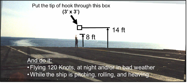
Wayne explained that the success of such a system requires extreme accuracy under severe conditions. Landing a plane using JPALS, a pilot must be able to place the tail-hook within a 3-foot by 3-foot box at the round-off, located 14 feet above the deck, while flying at 120 knots. This must occur in daylight, night time, good weather or bad. The ship can be moving along smoothly or in pitching, rolling and heavy seas. According to Wayne, the approach path for aircraft equipped with JPALS, is not just trying to land on a carrier in poor weather conditions. It is developed to land the plane on a 2-inch by 2-inch target on the carrier deck.
The following table compares JPALS with earlier systems
eJPALS
Wayne discussed the capability of utilizing the JPALS system for land-based operations. Installing the system at a new location or one infrequently used. The system developed is called Expeditionary JPALS or eJPALS,
The four-rack system installed on-board ship has been compartmentalized into four portable cases without redundancy. The accompanying GPS devices are mounted on tripods. The entire setup can be installed and operational within 2 hours.

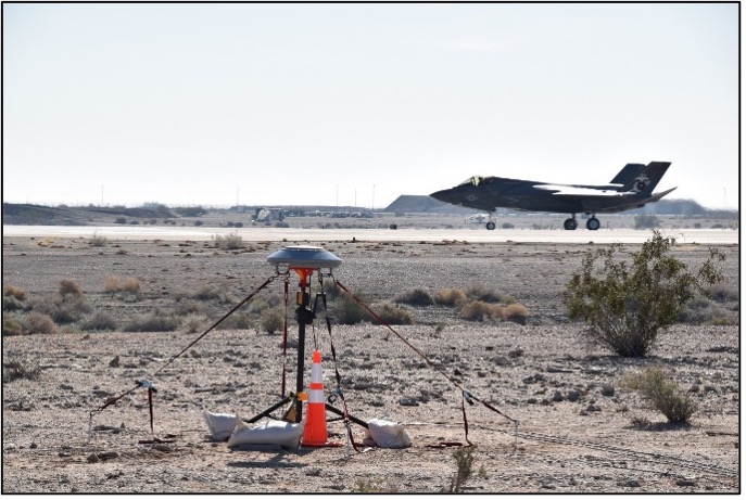
The portable system was flight tested by both experienced and new pilots and proven to be extremely accurate to a very small touchdown point on the airfield.
Latest Program Status
- Wayne indicated that JPALS had been deployed on the USS Wasp (LHD 1) to WESTPAC in 2017. Even though still in development, it was used extensively, including the launching of F35 strike missions.
- ePALS was demonstrated at MCAS Yuma in January 2019.
- In 2019 discussion was already underway with the UK, regarding acquisition of JPALS for their carriers (HMS Prince of Wales and HMS Queen Elizabeth). Additional discussion with Japan as well as other nations took place at that time.
- In addition to providing an approach path for fixed-wing aircraft, JPALS can also provide a hover point for rotary and STOL aircraft. It will enable aircraft in a hover to approach a landing platform to a point in space offset to the Port side and then move laterally to the selected touch-down point.
- Raytheon was awarded a $234M contract in May 2019 for 23 production systems.
- The first production system was installed on the USS Carl Vinson (CVN 70) in April 2020 and Operational Testing was completed in June 2020.
- ePALS has been considered by the US Air Force and the system is scheduled to be used during Operation Northern Edge 2021, military joint training exercise in May.
- Initial Operational Capability is scheduled for 2024 and Full Operational Capability in 2030.
QUESTIONS
- Is the F-35 the only aircraft to be equipped with JPALS?
The initial contract was to equip fixed and rotary wing aircraft in the US Navy. However, budget cuts in early 2000 made the program cost prohibitive. The JPALS project only included the F-35B/C and the Stingray UAV Tanker. Discussions are currently underway to consider adding JPALS to F-18 and V-22, due to its proven success.
- How low can an aircraft fly at a distance from a carrier, particularly rotary type and still use the features of the system?
Height above sea level is not a factor, since the signal is GPS based. As long as you are in UHF radio range, you can use the system for range and bearing to the landing zone.
- Can helicopters or other rotary wing aircraft use the system to approach and land on a platform on other than a CVN and LH?
The system was created for all platforms and can be used on other types of ships.
- How is the system protected from jamming interference during operations?
There is a significant level of anti-spoof and jam resistant capability. A newer coding structure that is more jam resistant and encrypted can be added.
- What is the maintenance or service replacement time for equipment?
Once identified and tested, the faulty part could be replaced within 30 minutes.
- Would the system be available within civilian markets?
An existing system WAAS (Wide Area Augmentation System) using GPS is available for the civilian market. WAAS provides service for all classes of aircraft in all phases of flight, including enroute navigation, airport departures, and airport arrivals. It is not certified for full autoland. The military accuracy would not be available for civilian use.
- What would the pilot see on the heads-up display in the cockpit using JPALS?
JPALS feeds the existing system. You are flying needles and will see deviation from required path. Once you have a view of the landing zone, you fly it visually to touch-down. If weather conditions prevent the pilot from visually seeing the touchdown point, the system can use the Autoland feature to land the aircraft.
- How does an onboard air traffic control system identify a JPALS equipped aircraft?
The aircraft will be identified on the display in the air traffic control center with a ‘J’.

 McKie Salley (US Army Infantry, Ret.)")
