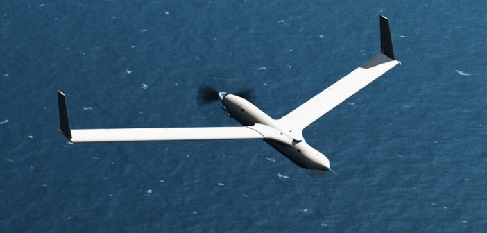
 Gramps heard a really different story told this month. It was the story of how a project designed for the tuna fishing fleet ended up as an efficient and highly useful military drone that is being used extensively in the field. Our speaker was Michael Kurth who is the Vice President and General Manager of Unmanned Airborne Systems Programs, a Boeing subsidiary.
 The story begins with a garage project by private individuals to produce a drone that could be used by the tuna fleet to replace the very expensive helicopter service that was used to search the ocean for tuna schools for the boats to catch. It used a model aircraft equipped with an onboard camera and was actually built in a garage. It passed a launch test and a sea test and flew from Newfoundland across the Atlantic on 1½ gallons of gas. It was noticed by the CG of the 1st Marine Expeditionary Fleet.
This  “Tuna Drone” was sent to work in Fallujah, Iraq as the “Scan Eagle”. The CG of the 3rd Marine Air Wing was in charge. It was deployed and had characteristics that were very valuable, such as its very quiet operation and near invisibility at low altitudes. It’s loiter time was 18 hours. A small, fixed wing aircraft, it was launched using a pneumatic launcher, thus not requiring a landing strip for takeoff or landing. The landings were accomplished by flying the drone into a rope hanging from a high pole. The drone’s wing would fly into the rope which would slide to the end of the wing where a hook waited. It would then be lowered to the ground intact. It was used on Navy ships and carried a camera and a signal tracker. It was also used by the Australian military.
 In 2008, the firm that was producing the drone, “In Situ”, was acquired by Boeing. It had a 750 thousand flight hour history. A second larger aircraft was similarly designed that weighed 3 times as much as the original but would carry 8 times the payload. This was known as the “Sky Hook” and uses GPS to recover to its starting point. Its picture resolution is such that it can read a license plate from 1.5 miles away!
 The originators are still inventing and creating software for unmanned flight. These drones now are highly autonomous and can be controlled by satellite or line of sight transmissions. They are designed for automatic recovery so that they will return to base even if communications are lost. In the future, there are plans to go to electric power which will make them even more stealthy.
 We thank Mike for this fascinating look into an unusual turn of technology that is clearly of great value. Your reporter has seen quite a bit of this technology as it is being investigated by law enforcement and it is truly amazing, even in the civilian realm.


